Transphoto

Kuvat julkaistaan sellaisina kuin ne ovat eikä niiden tarkoitus ole tukea kenenkään/minkään tahon poliittista tai ideologista asemaa.

Kaikki aineisto on peräisin käyttäjiltä eikä kerro sivuston ylläpidon mielipiteistä.

Sulje
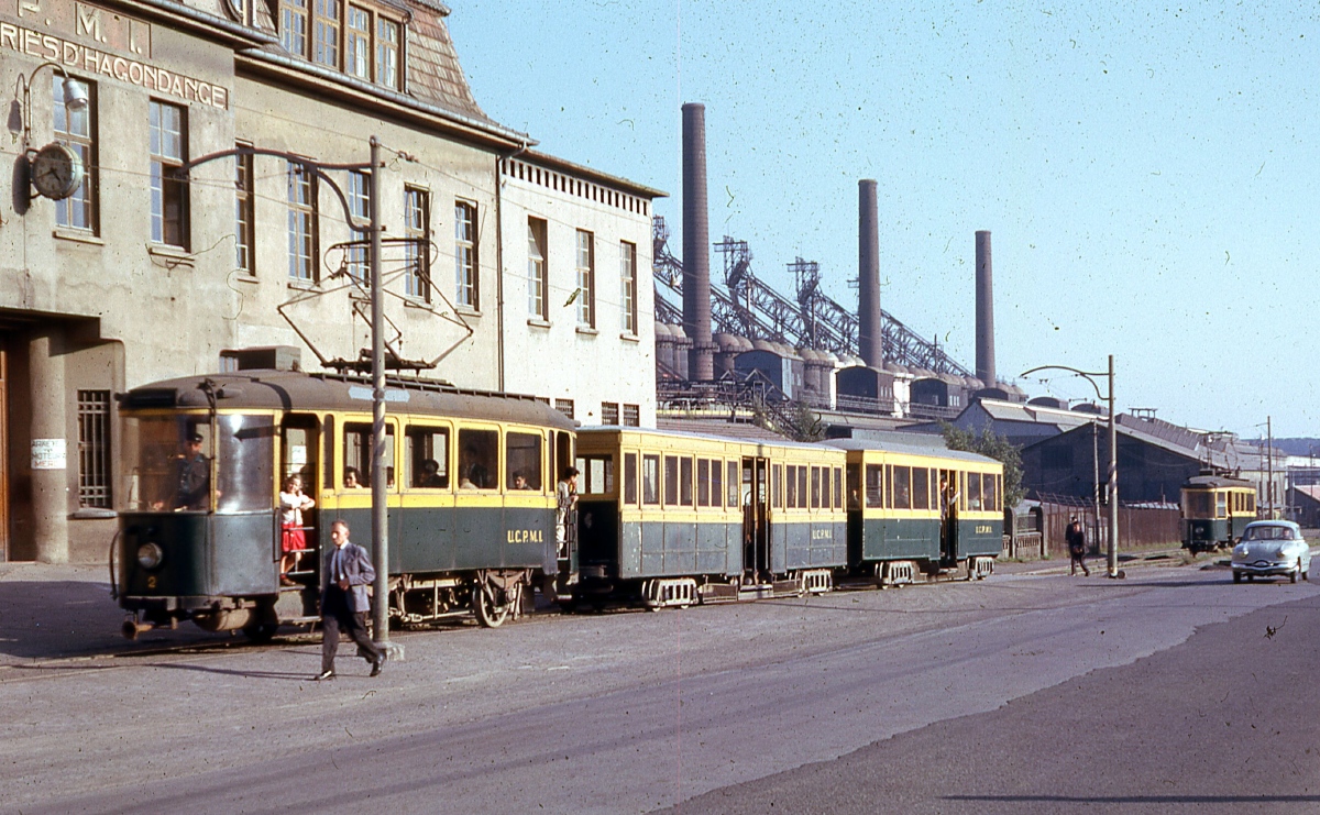
Hagondange, AEG 2-axle motor car # 2
  Hagondange AEG 2-axle motor car # 2 
Principal
Photo from my diapo

Kuvaaja: Tatralover           Kuvauspäivä: heinäkuu 1962 v.

Näytä kuvauspaikka kartalla

Tilastot

Lisenssi: BY-NC-SA
Julkaistu 05.04.2021 14:03 MSK
Näyttökerrat — 711

Tarkemmat tiedot

Hagondange, AEG 2-axle motor car # 2

Liikennöitsijä/varikko:Union des Consommateurs de Produits Miniers et Industriels
Malli:AEG 2-axle motor car
Valmistettu:1912
Nykytila:Poistettu
Käyttötarkoitus:Matkustajakulkuneuvo
Huom.:???? ex 3

Kameran asetukset

Artist Name:Picasa
Date and Time:23.06.2020 15:55
Näytä kaikki EXIF-tunnisteet

Kommentit · 6

05.04.2021 18:06 MSK
Linkki
Ymtram · East Haven - Branford
Kuvat: 18075 · Kolmansien osapuolten kuvien tarkastaja / Kuvien tarkastaja / Yleinen kalustotietokannan ylläpitäjä / Uutistoimittaja / Käyttöliittymän kääntäminen (EN)
Unbelievable, unique photo. Many thanks. Looking forward to more photos like this )
+3
+3 / –0
05.04.2021 21:01 MSK
Linkki
focus1965 · Antwerpen
Kuvat: 7636 · Yleinen kalustotietokannan ylläpitäjä / Käyttöliittymän kääntäminen (EN/FR)
Also from me: many thanks, un très grand merci !
+2
+2 / –0
12.01.2022 13:59 MSK
Linkki
L62 · Zaporižžja
Kuvat: 1591
Are the location coordinates marked correctly?
0
+0 / –0
12.01.2022 16:25 MSK
Linkki
Kuvat: 743
The location coordinates is absolutely good
+2
+2 / –0
12.01.2022 22:01 MSK
Linkki
L62 · Zaporižžja
Kuvat: 1591
0
+0 / –0
12.01.2022 23:55 MSK
Linkki
focus1965 · Antwerpen
Kuvat: 7636 · Yleinen kalustotietokannan ylläpitäjä / Käyttöliittymän kääntäminen (EN/FR)
I think that the coordinates are almost correctly indicated, but not quite right, and that the author is confusing the existing railway line with the former tramway.
The name of the factory can be read partly on the building and fully on the trams: the tram line belonged to the factory: UCPMI.
The author noted 'principal' and this means it was the main entrance, which is very plausible given the size of the building.
Thanks to Google and Wiki, I tried to locate the former factory: everything has since long been demolished, but that always opens up perspectives: the scars in the landscape remain.
https://fr.wikipedia.org/wiki/Usine_sid%...ondange
On this wiki page, the location is also present. If one then selects Google, one can also view the satellite images.
What do we find in this environment? A lot of undeveloped land, typical when a whole factory has been demolished: the land is so polluted that little can be done with it. But also a cultural centre called "The Tram". That is, of course, no coincidence. https://letram-maizieres.fr/ The location can be found on Google Maps. It has nothing to do with a (or the) tram, but at least: it was running somewhere there.
Again: where was the main entrance? The red marker on Google Maps (see Wiki Page) is in the middle of the factory and not the entrance itself.
This is a guess because a small part of the factory still exists to the north. To the east is a railway line: the entrance can therefore never have been located there. Westwards is particularly logical: there are still streets there and the landscape also shows that 'something' must have been there.
The exact location is more to the north, somewhere where the roundabout is now, north of the new amusement park: another thing that is always thought up when a factory closes...
https://goo.gl/maps/5FGPvCHGcF6eNXyh6
It is just a guess, but this was done by deduction. There are other possibilities too, but they will certainly be in the immediate vicinity. Not only the factory and the tram have disappeared, but also streets have been added.
+3
+3 / –0

Kommenttisi

Älä keskustele poliittisista aiheista tai sinut estetään kuukaudeksi.
Sinun on kirjauduttava sisään kirjoittaaksesi kommentteja.