


 Sähköinen kaupunkiliikenne
Maps
Liège
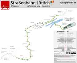 |
Source: www.gleisplanweb.eu marraskuu 2023 v. |
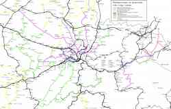 |
Map of the N.M.V.B./S.N.C.V. in and around Liège (city and province) in 1940 (non-electrified lines; green and yellow when out of the province) and 1951 (electrified lines; pink and orange when out of the province. Black = N.M.B.S./S.N.C.B. (railway). 1951 v. |
Näytetyt kuvat: 2 / 2
Kuvat ovat tällä hetkellä kuvauspäivän mukaisessa järjestyksessä (uusimmat ensin).
Tumma tila
© TransPhoton ylläpito ja kuvaajat, 2002—2024
Minkä tahansa sivuston kuvan käyttö ilman kuvaajan lupaa on kielletty.
Minkä tahansa sivuston kuvan käyttö ilman kuvaajan lupaa on kielletty.