


 Elektrischer Nahverkehr
Maps and Plans
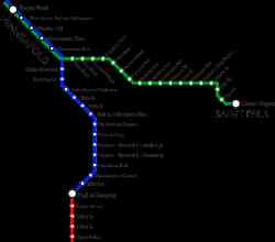
Minneapolis–St. Paul
 |
Author: Senori 25. Juni 2014 |
 |
Map Showing the Lines of the Twin City Rapid Transit Co., Minneapolis and St. Paul, 1913 . 1913 |
 |
Chicago — Maps and Plans Chicago . 1906 |
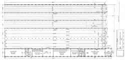 |
Plan of Snelling Avenue Car House . 1904 |
 |
Map of Minneapolis, St. Paul and vicinity . 1894 |
Dunkelmodus
Jegliche Nutzung der Fotos dieser Webseite ist ohne Zustimmung der AutorInnen nicht gestattet.