


 Linnade elektritransport
Maps
Munich
 |
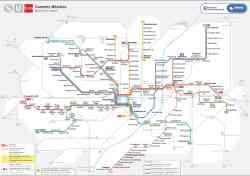
Alternative Map of Munich Underground and Suburban Trains (Sark Version) 15 detsember 2024 a. |
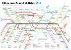 |
Alternative Map of Munich Underground and Suburban Trains 15 detsember 2024 a. |
 |
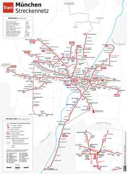
Liniennetzplan Straßenbahn München, gültig 2024 • Схема трамвайной сети Мюнхена, действует в 2024 году • Scheme of tramway network in München, valid in 2024 2024 a. |
 |
Tramnetz München 21 september 2019 a. |
 |
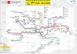
License CC-BY-SA 2.0 Detsember 2018 a. |
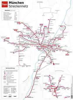 |
Схема трамвайного сообщения / Schema Straßenbahnlinien 2014 a. |
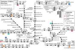 |
Схема путевого развития Мюнхенского метрополитена Detsember 2010 a. |
 |
License CC-BY-SA 2.0 1997 a. |
 |
License CC-BY-SA 2.0 1964 a. |
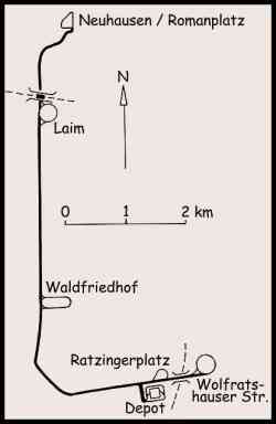 |
Map of the Munich trolleybus network, consisting of the solo Line 032 (later 58). 25 oktoober 1959 a. |
 |
License CC-BY-SA 2.0 1914 a. |
Tume teema
Sellel saidil ilmunud fotode ja muude materjalide kasutamine on lubatud ainult nende autorite loaga.