Mapy / Maps
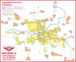 |
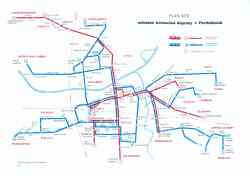
Schéma linkového vedení MHD v Pardubicích, platné k 1.7.2022.
Trolejbusová linka č. 1 byla odkloněna, ze své běžné letité trasy, přes sídliště Dukla po nové trati přes nadjezd PARAMO k Nádraží.
Scheme of public transport lines in Pardubice, valid at 1.7.2022.
Ttrolleybus line No. 1 has been diverted from its regular, long-standing route through the Dukla housing estate
along the new track via the PARAMO overpass to the Railway Station.
Zdroj / Source: DPMP
2022 m. liepos 1 d.
Atsiuntė 9TrL194
|
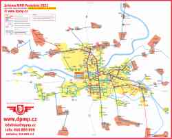 |
Schéma linkového vedení MHD v Pardubicích, platné k 12.12.2021.
Probíhá výluka nadjezdu u Nemocnice, což ovlivňuje trasy trolejbusových linek 1, 2 a 12.
Scheme of public transport in Pardubice, valid at 12.12.2021.
The road overpass across railway by the Hospital is closed because it is under reconstruction. This situation affects the routes of trolleybus lines 1, 2 and 12.
Zdroj / Source: DPMP
2021 m. gruodžio 12 d.
Atsiuntė 9TrL194
|
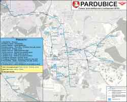 |
Схема троллейбусного сообщения
2010 m. Spalis
Autorius: Road_Runner
|
 |
Dobové schéma MHD v Pardubicích v roce 1990.
Scheme of urban transport in Pardubice in 1990.
1990 m. (maždaug)
Autorius: 9TrL194
|
 |
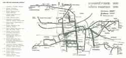
Dobové schéma MHD v Pardubicích v roce 1980.
Scheme of urban transport in Pardubice in 1980.
1980 m. (maždaug)
Autorius: 9TrL194
|
Rodoma nuotraukų: 5 iš 5
Nuotraukos surūšiuotos pagal fotografavimo datą, viršuje - naujausios.
Į sistemų sąrašą
| 


 Elektrinis miestų viešasis transportas